
Feeling like I needed something more in my B-semester, I started talking to some friends about going hiking, and toyed around with the idea of working up to the Tongariro Crossing, but still in the back of my mind, it was a bit of a pipe dream. As the semester rolled away, my self doubt turned into excuses and I convinced myself that I wouldn't have time to do the hike, but then when my childhood best friend Tanya planned a trip to visit me before I left New Zealand, this was at the top of my list of things to do, so I planned a trip to Tongariro and invited some friends to join.
Our group consisted of me, Tanya, Silje, Linn, and Hannes. Ashley was supposed to join us, but ended up spraining her ankle a week before the trip, and had to cancel. We also picked up a group of guys, but being stereotypical Norwegian outdoorsmen ;) their hiking pace and desire to climb mountains covered in snow exceeded the rest of us, and they went off on their own to climb Maunga Ngauruhoe aka Mount Doom.
*Side note, never show up to a hike in jeans when with Norwegian people (it's not a big deal in Hawai'i okay)
Our day went a little something like this - and the times are just a guesstimation
2:45am: wake up
3:30am: girls and Hannes ready to leave
Now before we go on, I have to mention that we were planning on leaving Hamilton at around 4am, but the guys thought that it would be a better idea to leave at 3am, so we made a compromise to leave at 3:30
4am: GUYS are still not ready to go
4:15am: after much discussion figuring out their GPS, the guys are finally ready, but need to fill up on petrol. Finally we were off, the guys with their GPS insisting on leading the way. On the drive we ended up taking some random side roads in the middle of the night, barely making turns, missing turns and pulling U-ies, etc. etc. I should have lead the way using the maps on my phone.
6:55am: we actually get to the shuttle station almost on time, only about 5minutes late! On the way the driver gave us his little speech, "today is about having fun, if at any point it stops being fun, if you haven't reached the red crater, it's best to turn around and come back, if you've passed the red crater, it's best to just keep going."
7:30am: start hike
7:32am: Silje already sick of her hiking stick
7:35am: too hot, time to remove a layer, first fika (Linn's acclaimed most important Sweedish term meaning, well anything really, but in this case meaning a rest bit)
7:40am: guys (except Hannes) are gone
After this, I kinda lost all sense of time until the very end.
The first part of the hike was nice and gradual, most of it on a boardwalk alongside a stream.

We decided to fika because the backdrop was amazing and we had a great view of Mount Doom in the background. Begin jumping pictures in front of Mount Doom.

This was before we knew what was in store for us up ahead.
The first difficult part of the hike was dubbed the "Devil's Staircase" quite appropriately. At the start of this leg of the hike was a sign reading something to the effect of, "STOP! Are you sure you want to continue?" I really wish I took a picture of it, it was not the most encouraging sign.
The Devil's Staircase was pretty tiring, and we had to stop and take a few fika on the way to catch our breath. When we finally got to the top, we knew that the hard part was still to come. An older man overheard us and offered "do you want to hear the truth or good news?" I wanted the truth. He told us that there were two really hard parts on the hike, and that (as he points down toward the Devil's Staircase) was one of them. Okay, cool. That's manageable.
After a little bit of an incline for a while, we approached what we assumed to be the second hard part. This uphill climb to Red Crater peak of the crossing was a tough one and super sketchy in some places, especially with so many people on the trail one right behind the other. If you fell, you would most likely take out a bunch of people with you, and lucky me, I was up in front with all my friends behind me. I kept thinking about how terrible I would feel if I rolled back on all of them.
Just to give you a visual, the Devil's Staircase is that first really steep incline between the Soda Springs and South Crater, and the second rough part is the one up to the Red Crater.

The Red Crater was really cool, and once you got to the top, you got a stunning view of the Emerald Lakes below.


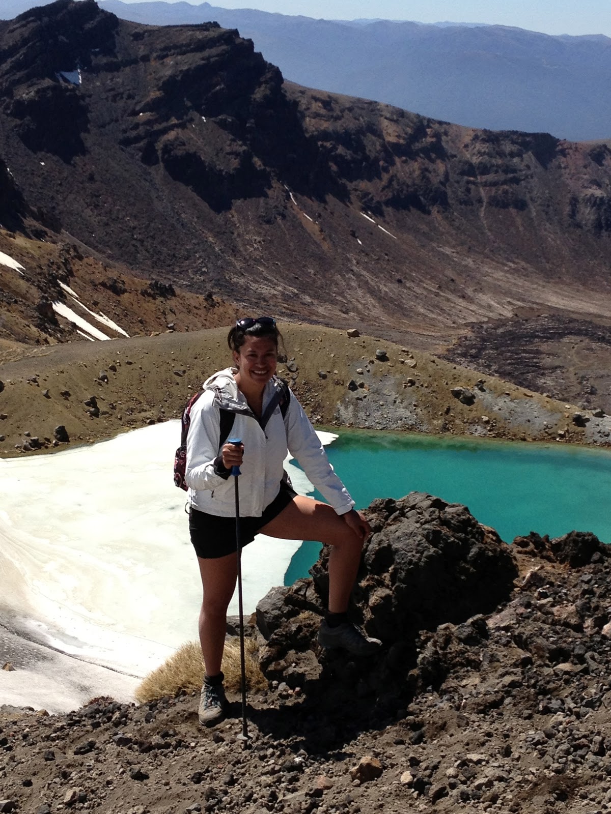
As you can see, part of the lakes were still frozen over as New Zealand is currently in the Spring season heading into Summer. It was actually kind of a bonus for me to see the mountains a little bit snow covered, it was like getting to experience Tongariro in two seasons.
The next part of the hike way more of an attempt not to lose your footing as you practically slid down the ashen mountain. I found that it was easier to just walk it sideways and let it be. The more I tried to control my footing on this part, the worse it seemed to be, so I just slid my way down step by step, trying to keep a steady pace. This way yet again another really sketchy part of the crossing.
When we got to the bottom at the Emerald Lakes, we took our lunch break and sat by the glittering water. I was so tempted to jump in, it looked so enticing, but jumping into a lake of sulphuric acid is not the best idea, so I had to be satisfied with the view.

The next part of the hike was the most hilarious, we had to trek though quite a long way though snow that was semi melted because of the summer sun, did I mention that we had unbelievable fantastic weather that day? Seriously, it couldn't have been any better. As we were walking through the snow Hannes commented that "this must be what it's like to walk around when you are drunk" which he was totally spot on about. What made the whole situation harder was that once he made that comment I couldn't stop laughing at how ridiculous I must have looked. And of course, because I was laughing so hard, I wasn't making the best footing choices, which would make me stumble through the snow even more, which would make me laugh even more, all the while running out of breath from laughter and general exhaustion.

Once this stretch was done, it was over yet another hill, and then we had to walk along the steepest hill of snow on the narrowest pathway of melting snow, now that was by far the most sketchy part of the whole trek. I took a picture, but it doesn't really give you any perspective on the steepness, and I was too sketched out to take another pic and hold up the people behind me.
When we finally got to the Blue Lake, which was still completely frozen over, it was all downhill from there, sort of. As I had heard before, the last part of this hike is the worst. It didn't seem so bad at first getting from the Blue Lake to the Ketetahi Hut across the site of the most recent eruption on August 6th. We often passed signs reading, "WARNING" something about an active volcanic site, "walk quickly, avoid taking breaks." Sure it was long and full of switch backs, but it was nice to know that we wouldn't be climbing up any more steep mountains. Just when the downhills were starting to get to my knees, we reached the hut and had another fika. Good opportunity to empty the shoes and socks of all the accumulated debris.
Side note, I wore the WORST socks ever for this hike. I was thinking that it would be a good idea to wear some high knee socks in order to keep the debris from getting in between my toes and what not. Too bad the socks I chose to wear are made out of the worst material ever and all the dust and tiny rocks went THROUGH the material to settle in between my toes anyway. In addition to that mess, every time we walked though snowI would get bits of ice in my shoes and it would melt to make a nice little soup.
After the fika at the hut, we continued our descent thinking, it must be almost over. WRONG. THIS was the worst part of the entire hike, it seemed to never end, and this time the scenery wasn't all that much to look at. We hiked forever through dry bush, and not much else with no promise of an end in sight. THEN, another set of stairs going UP!? What? I thought we were only going down from here!
FINALLY, the bush turned into a jungle, which was a welcome change of scenery for me and really reminded me of home.

The rest of the hike went a little something like this:
The part where we were in the jungle.

The part where the jungle ran alongside a stream.

The part where we had to take a detour through the jungle because of the recent lahar mudflows.
By this point we were starting to feel like we were so close, and yet so far! Every time we thought it was over, we would run into something new.

The part where the stream and the pathway became one.
We hiked through a bit more of this jungle, and I could feel the blisters about to form on my feet, and my knees being really angry with me. There was a rock pressing against the bottom of my foot, but I was so determined to finish this hike and felt like stopping at this point would make it so much harder to continue.
I looked at my watch, if we got out of this jungle in the next 10 minutes, we will have finished the Tongariro Alpine Crossing in just about 7 hours. That's two hours less than I was expecting, and right now I was feeling like I could not do another two hours of this.
7 hours and about 15 minutes later, WE MADE IT!!!!! and no one had enough energy to take a picture of our success, haha.
No comments:
Post a Comment